Travel and Transportation
Updated: Jun 28
From Indian Trails to Modern Travel
Roads
The first roads in Chester County were the old Indian trails, and succeeding highways were laid out from time to time by the county court. Early court orders required property owners to extend possible roads through or adjacent to their lands. An early municipal function was the connection of these roads, which was well underway by the late 1700s. After the Revolutionary War, the Philadelphia and Lancaster Turnpike Company was chartered; it completed the turnpike in 1794, at a cost of $7,516 per mile. Strasburg Road was constructed in the 1780s, and these roads put Sadsbury Township on major regional routes for the transportation of goods and agricultural products.

The Philadelphia and Lancaster Turnpike (now known as U.S. Route 30), opened to the public in 1795, is the first long-distance paved road and the first turnpike ever built in the United States. It was the first turnpike of importance, and because the Commonwealth of Pennsylvania could not afford to pay for its construction, it was privately built by the Philadelphia and Lancaster Turnpike Road Company, making it an early example of a public-private partnership for American infrastructure. By 1795, the completed turnpike to Lancaster required tolls and had been paved with layers of crushed stone, widened, straightened, and engineered for good drainage.
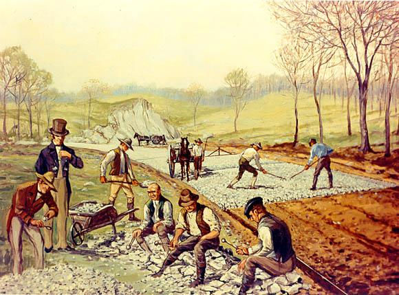
The Philadelphia and Lancaster Turnpike marked the first use of a macadam road surface within the United States. John McAdam invented this new form of pavement in Scotland, while serving as a road trustee in Bristol, Southwest England. There were three other early turnpikes built in the county: the Downingtown, Ephrata and Harrisburg Turnpike, commenced in 1803; the Gap and Newport Turnpike in 1807 (now known as Route 41), and the Little Conestoga, in 1809 (now known as Route 401).

By the 1840s, the use of railroads and canals dealt a serious blow to the companies that specialized in the manufacture of wagons and coaches. During the next fifty years, the Philadelphia and Lancaster Turnpike suffered from lack of use and maintenance but later saw recovery with the invention of the automobile.
In 1913, the turnpike became part of the Lincoln Highway, America’s first transcontinental highway. Tolls continued to be collected until 1917, when the State Highway Department bought it for $165,000, equal to $3,768,857 today. In 1926 it was designated as part of U.S. Route 30 along with the rest of the original United States Numbered Highways.


US 30 was widened into a multi-lane road through Chester County in the 1930s. In the 1960s, the US 30 designation was moved to a bypass highway around Coatesville and Downingtown.
Railroads
The opening of the Erie Canal in 1825 suddenly diverted Philadelphia’s trade with the West to New York. The Commonwealth of Pennsylvania built the Philadelphia and Columbia Railroad (P&CR) during a time when America's main coastal cities were vying to become the most important and influential port on the East Coast. The goal was to position Philadelphia to be the principal supplier and beneficiary of the post-Revolutionary War economic boom.
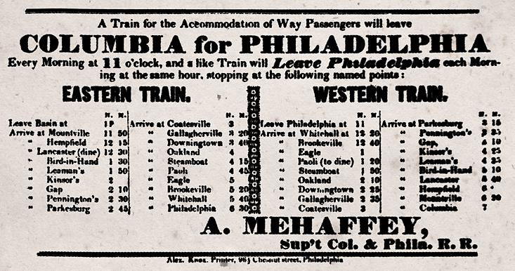
The Philadelphia and Columbia Railroad was the first railroad built through Chester County. It was one of the earliest commercial railroads in the United States, running 82 miles from Philadelphia to Columbia, Pennsylvania (on the Susquehanna River just west of Lancaster). It was built by the Pennsylvania Canal Commission in lieu of a canal from Columbia to Philadelphia. It became operational on September 20, 1832, using flanged-wheeled carriages and wagons dragged by horses atop iron-capped wooden rails.

Built with public funding, the double-track railroad originally operated on a turnpike basis which opened it to everyone, with shippers supplying their own rail carriages, wagons, horsepower, and drivers. The railroad soon decided to offer the option of new-fangled steam locomotives to haul the carriages and wagons assembled into trains, which ran interspersed between horse-hauled traffic. By 1837, the number of engines using the track had increased from 3 to 40. The railroad located its locomotive and car shops at Parkesburg. By 1861, with expansion westward, the Pennsylvania Railroad moved the shops from Parkesburg to Harrisburg and eventually to Altoona.

Between 1830 and 1835, more railroad building was done in Pennsylvania than in any other state. The urge to preserve Philadelphia’s status as the merchant city of the United States resulted in some 200 miles of rails being opened during these years.
As it turned out, it was extremely expensive to own and operate a railroad that included tunnels, inclined planes, and canals. After $80 million in original construction costs and an additional $40 million in debt accumulated over 20+ years of operations, it was finally purchased by the Pennsylvania Railroad in 1857. It is now owned and operated by Amtrak as its electrified Keystone Corridor.
Pomeroy & Newark Railroad
The railroad line that became the Pomeroy and Newark Railroad began in 1873 as the Pomeroy and Delaware City Railroad and soon began experiencing financial problems. The line went bankrupt around 1879 and emerged as the Pennsylvania and Delaware Railroad. In 1881 the Pennsylvania Railroad acquired control of the Pomeroy and Delaware City Railroad and renamed it the Pomeroy and Newark Railroad. The Pennsylvania Railroad set about making repairs and improvements to the tracks, trestles, and bridges used by the line.
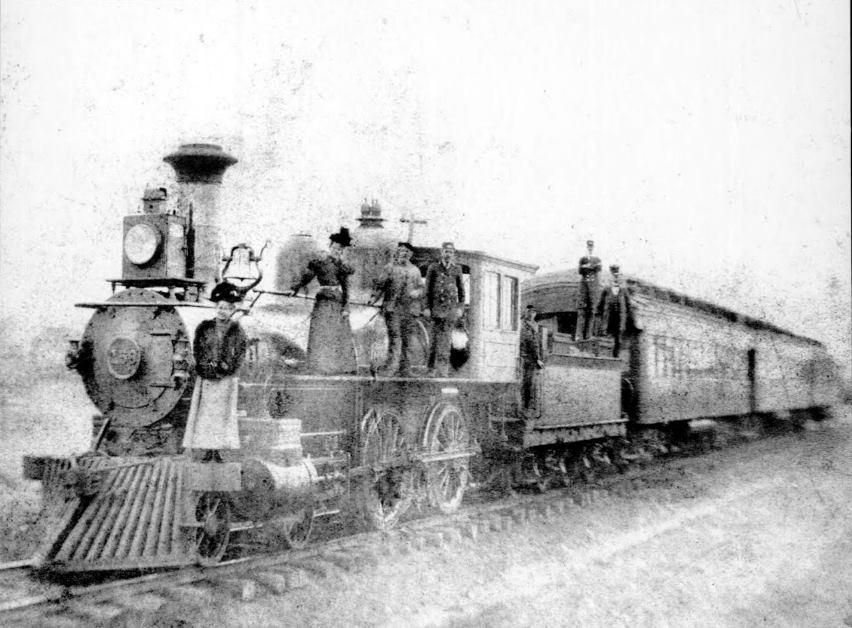

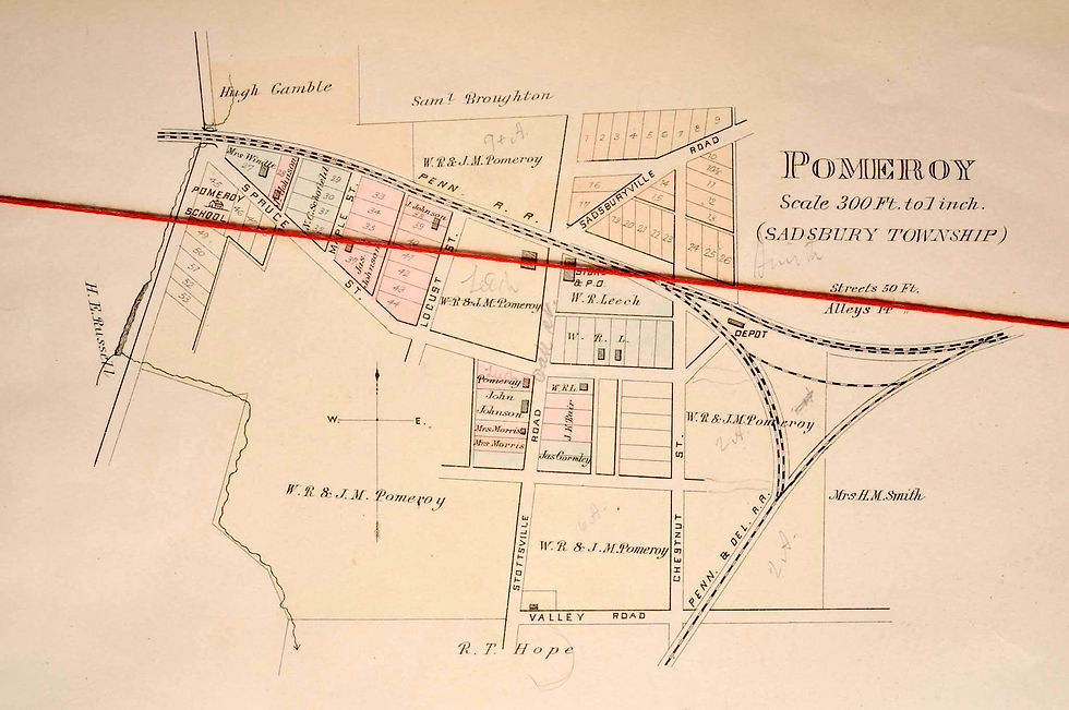

For years, the Pomeroy and Newark line combined passengers and freight on the same trains, which could sometimes run as much as two hours late. By 1901, patrons of the Pomeroy and Newark line welcomed “a new passenger train which runs on schedule time and makes connections nicely”. Between 1907 and 1927, there were two trains a day between Pomeroy and Newark; one scholar estimates that there were never more than 20 people on any one train.
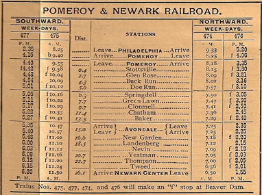
Starting in the 1920s, improvements to local roads along with increased automotive and truck activity began to lead to a decrease in all traffic and revenue on all railroad local branch lines.
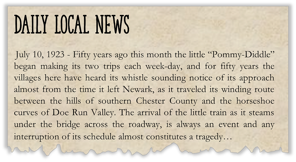
In the late 1920s and early 1930s, the post office cancelled many mail contracts and moved the mail transport to trucks. Once the mail contract was ended, passenger services was cut to one train per day either way.
In 1928, passenger service was discontinued, despite pleas to the Pennsylvania Railroad from farmers and businessmen. Given the tight turns and weight limitations on the bridges and trestles on this branch, the newer and heavier equipment could not be used. Maintenance was a challenge since the line followed streambeds and the occasional high water would wash out and weaken the supporting structures and sometimes the rail bed itself. Freight service continued until the line was abandoned; the final abandonments occurred in the late 1960s.

Coatesville Airport
The Coatesville Airport opened on May 1, 1928 and was owned and operated by the City of Coatesville. In the late 1930s, it became a stop on one of the early experimental air mail routes.
In 1938, All American Aviation secured a contract with the U.S. Government to provide experimental air mail service to small towns in Pennsylvania, Delaware, West Virginia, and Ohio. The purpose of the experimental service was to test the feasibility of feeder lines where airport facilities or volume of mail were insufficient to justify full air mail service. All American staged a number of demonstration pickups and deliveries at selected points along its planned routes, and the first such event was held at the Coatesville Airport on March 6, 1939. More than 2,500 people including journalists; airplane, rope, and steel manufacturers; mail handlers; and curious onlookers attended the event.

According to a Time Magazine article from March 20, 1939, a rope with mailbag attached to it was stretched between two 40-foot poles 50 feet apart. An airplane trailing a hook on a cable from its belly passed over the rope between the poles. A bag of Coatesville mail was tossed out of the airplane, and the dangling hook snagged the stretched rope with the mailbag attached, and the mail clerk in the plane hauled the bag aboard the plane with a winch for sorting. This service was used in these areas for about ten years. All American Aviation later became Allegheny Airlines and then US Airways.


During the Depression, Civil Works Administration funds were used for improvements at the airport and pilots were trained in ground schools there prior to World War II. During the war, activity was severely curtailed by government restrictions on civilian flying along the Atlantic seaboard. Following the war, pilots trained under the GI Bill.
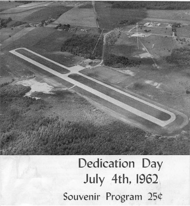
In 1958, the airport was purchased by the newly organized Chester County Airport Authority, which took over operations. It was renamed to Chester County Airport, then renamed again in 1962 to Chester County G.O. Carlson Airport, in honor of the Authority’s first chair. Carlson had founded G.O. Carlson Company in 1936, which became an innovator in steel manufacturing and stainless-steel production with operations in Coatesville at one time.
Sources:
https://en.wikipedia.org/wiki/Philadelphia_and_Lancaster_Turnpike
Biographical and Portrait Cyclopedia of Chester County, Pennsylvania, by Winfield Scott Garner and Samuel T. Wiley, 1848.
The History of the Pennsylvania Railroad, by Timothy Jacobs, 1988.
When Railroads Were New, by Charles Frederick Carters, 1909.
Chester County, by Chester County Historical Society
The Airway to Everywhere: A History of All American Aviation, 1937-1953, W. David Lewis and William Trimble, 1988.
https://postalmuseum.si.edu/exhibition/airmail-in-america-the-airplanes/stinson-reliant-and-the-mail-pick-up-service (National Postal Museum, Smithsonian Institute)
The Pomeroy and Newark Railroad (The Railroad That Should Never Have Been Built), Jack Hill, 2023.
New Garden Historical Commission, The Pomeroy and Newark Railroad http://historic.newgarden.info/index.htm
Gregory D. Pawelski, Facebook, PRR Pomeroy Branch
Sadsbury Township 2013 Comprehensive Plan


